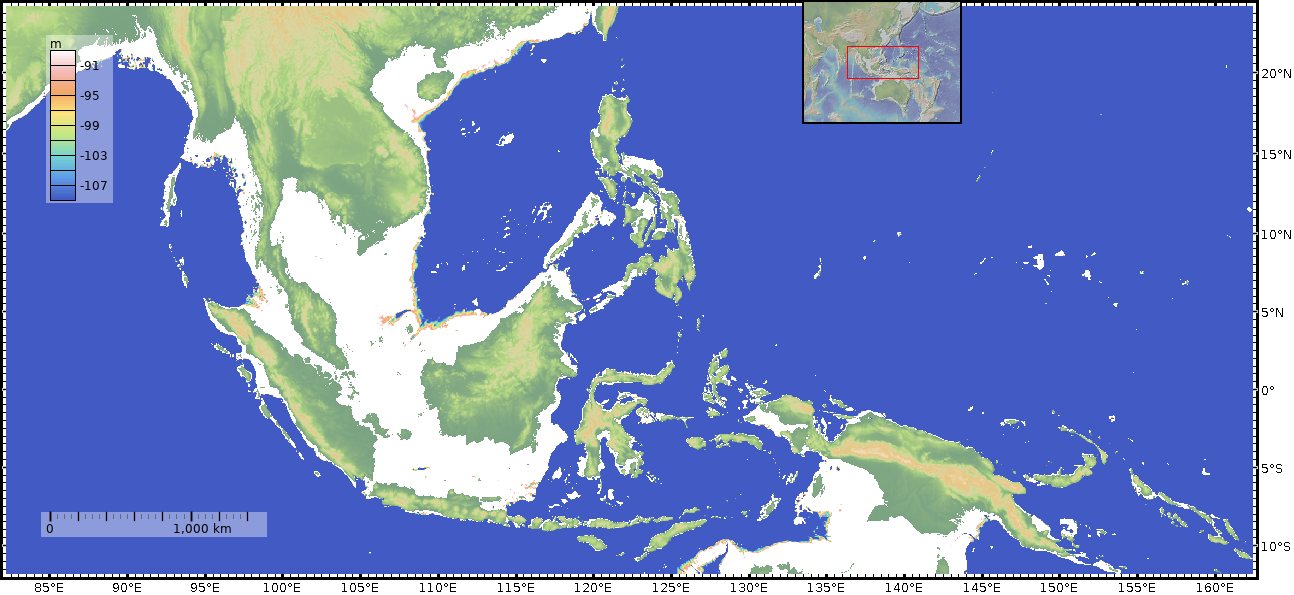
With the recent announcement of another quite old, non-human hominoid in SE Asia, once again people are asking questions about how such humanoids got there, as if these non-human animals were stupid, or incompetent, or ... whatever reason.
So, I did a bit of bathymetry work, since I've got tools to hand. I'm sure I'll use these again.
The common estimate for the decrease in sea level (compared to today) at the height of the last ice age, is 100m, so I've adjusted the rainbow colour scale to cover the 90-110m range ; anything deeper than that is marked in blue ; anything shallower is white ; present day exposed land is given an altitude palette.
This next picture I just anticipate I'll need at some point. Constructed from the same data (GMRT) and with the same shading to differentiate 100m+ versus 100m- water depths, it shows the context of the Homo Floresiensis discovery site (Liang bua cave, my typo). You will note that at least one water crossing of about 30km or larger is needed to get from mainland Asia to Liang bua.
The sea to the north of the two Nusa islands is known as the Flores Sea, for which the species was named.
Plots done using GeoMapApp, www.geomapapp.org and the GMRT dataset they pick up.
So, I did a bit of bathymetry work, since I've got tools to hand. I'm sure I'll use these again.
The common estimate for the decrease in sea level (compared to today) at the height of the last ice age, is 100m, so I've adjusted the rainbow colour scale to cover the 90-110m range ; anything deeper than that is marked in blue ; anything shallower is white ; present day exposed land is given an altitude palette.
Is Luzon isolated from the mainland by deep water?
On this first plot, there is an obvious wide gap to the north. It actually goes down to several km depth, but since you normally drown in the top few metres of water, that doesn't really matter. The minimum sea passage is several hundred kilometres. That's quite a challenge.
Moving to the southern approach, the question is more complex. At a 100m lower sea level, there is no "dry" route to Luzon, but several of the channels are down in the few-tens of km width. These would certainly be easier for people to have crossed, regardless of their species. Whether that is how the Luzon hominids got in ... is at the moment a judgement call. But if I were looking for places to search for bone-bearing deposits, that's where I'd start.
The sea to the north of the two Nusa islands is known as the Flores Sea, for which the species was named.
Plots done using GeoMapApp, www.geomapapp.org and the GMRT dataset they pick up.


No comments:
Post a Comment
Please add any useful comments you have. Some HTML allowed. All comments go through moderation (because : spambots).