2023 May Science Readings
May the 11th, and I have only just started. This isn't going to be a productive month.
A bit of progress by thw 18th.
I've got my keyboard better set up for accenting etc, and that's worth remembering. But it's not really a thing for this page. And I need to work on the redshift calculator (online version). [I still can't see what I was concerned about.]
Well, now I've got a problem. Why are my changes to my CSS not updating?
P …
Back to List.
WTF is a "Magrathea Planet"?
ArXiv : Statistics of Magrathea exoplanets beyond the Main Sequence
Do people these days need to reference that Magrathea is a fictional planet in Douglas Adams' "Hitchhiker's Guide To The Galaxy"? Hopefully not, but if so, follow the link.
From the radio series/ books/ TV series/ films, the planet is sufficiently Earth-like for an unmodified tea-drinking slightly furry English-person to walk across the surface, picking his way between the lumps of confused sperm whale, armoured in a slightly battered dressing gown. So, essentially, Earth-like.
But what is a "Magrathea planet", according to these astronomers? Well, I'm not sure exactly how they got from the book description to a "system[s] in which the planet survived the [white dwarf] formation of the stars in the binary."
In particular they're looking at planets around double-white dwarf systems, of which "No exoplanet has been found orbiting double white dwarf (DWD) binaries yet."
That terminal "yet" suggests they have some reason to believe that there will be an announcement, some time "soon". Watch, as they say, this space.
There is a hint in the books etc that the Magrathea "civilisation" (Adams' own expressed doubt) is quite old in human - and "galactic" - terms. Which goes with a relatively old stellar system … there are a lot of caveats to put in there, but it's fiction, so not worth getting too bothered about. These scientists seem to have priority on re-using the term in an astronomical context, and I guess we pretty much have to accept it. They're a moderately interesting type of planet, but ultimately not going to be that common, compared to main sequence star's planets.
The "gas giant" aspect of the definition is in contradiction to Adams' earth-like scenario, but does mean the class is of relatively detectable planets. The main difficulty is likely to be in finding "DWD" systems, because by definition, they're going to be dim. The closest WD to Earth is the Sirius (absolute magnitude +1.43) and it's companion WD, ("Sirius B" sometimes called the "Pup", absolute magnitude +11.83, on a 50-year orbit about the primary) which is about 10.4 magnitudes (a factor of 14400-fold) fainter. As a "DWD" system, we certainly wouldn't have spotted tis until the 1700s, if not 1800s, while as it exists today, it's the brightest star i nthe sky after the Sun.
As a class of planets, it's a logical class, and this is a name for it. But it's not ever going to be a particularly common class, compared to those around G0- or M- stars.
There are other science uses of "Magrathea" in software ("Magrathea-Pathfinder: A 3D adaptive-mesh code for geodesic ray tracing in N-body simulations") and experiment ("Magrathea: Dust growth experiment in micro-gravity conditions"). Both are in the field of "building planets", which was the business area of Adams' Magratheans. Which is all good fun.
Back to List.
Observational predictions for Thorne–Żytkow objects
https://arxiv.org/pdf/2305.07337.pdf
Well, I had to search my note to remind me how to type the (capital-Z-upside-down-caret) character. (It's Super-.,z on my machine.) But that's not the big point. What the fsck is a Thorne-Żytkow object? Thorne–Żytkow objects (TŻO) are potential end products of the merger of a neutron star with a non-degenerate star.
Ohh, so, the popular trope every time there is some science news about a black hole or neutron star, "What would happen if this entered the Solar system?
is right up this street.
There has obviously been theoretical work in the past on this, because the paper doesn't start with the NS entering a photosphere. They seem to have their NS already at the core of the "non-degenerate" star ("the Sun" for the Internet wail). Previous work (1975 to 1991) suggests that Depending on the mass of the combined star, it can be supported either via nuclear burning on/or near the surface of the NS and by accretion onto the NS.
Which is rather what you'd expect, if you think about it for a few seconds. The situation isn't that far from what happens to a NS in a binary system, as it accretes material from the non-compact star, except (this is important) there is enough material compressing the burning area to not go down the SNIA route of a thermonuclear "standard" candle, but it burns in a quasi-steady state. The normal scenario of a SNIa is for a white dwarf (WD) to be doing the accreting, but you could try doing it with a NS too. The difference in surface area between a WD (approximately Earth-size) and a NS (typically 3km in radius) is going to change things a lot though.
TZOs may be news to me (though I've got to say, I had wondered about the question myself, but never researched it), but they've been a subject of work since the mid-70s, have a Wiki page, and I (probably you too, dear reader, should you exist) would be best advised to read that first. A TŻO has an estimated lifespan of 10^5–10^6 years. Given this lifespan, it is possible that between 20 and 200 Thorne-Żytkow objects currently exist in the Milky Way.
answers several very obvious questions. What happens then? It has been theorized that mass loss will eventually end the TŻO stage, with the remaining envelope converted to a disk, resulting in the formation of a neutron star with a massive accretion disk.
Very well and good.
A candidate TŻO was proposed in 2014, and they've been linked to other classes of odd stars (Wolf-Rayet stars, RCrB variables ... ), but that attribution has been challenged with an alternative candidate proposed. There are now a half-dozen eight candidates, some of which are well-known RCrB variables.
From Wiki, they're also associated (potentially) with "strange" stars (in the quantum chromodynamics sense), and hence tetraquarks and pentaquarks, all of which have appeared in my reading lists over the last few years.
So, what does this paper add, now that I've dragged myself up to speed on the base phenomenon?
By using different computer models for the nuclear chemistry that would go on on the stellar core to NS boundary, this paper makes different predictions for the nuclear make up (and so, eventually, spectroscopy) of the star. And ... it's over to the observational astronomers.
I've dropped the data into the TŻO wiki page "talk" section. I've had too many snotty responses from Wikipeople to waste effort putting it in myself.
Dramatis Personae
An obvious question is, who are Żytkow and Thorne? I don't recognise Żytkow's name, but is the "Thorne" "Kip" Thorne of various GR and gravity text books? And indeed, it seems to be him. The other author, Anna Żytkow, is a new name to me. See her Wiki page.
Edit : connected to this article from Jan 2024.
Back to List.
Day ‘N’ Nite: Habitability of Tidally Locked Planets with Sporadic Rotation
https://arxiv.org/pdf/2303.14546.pdf
Quite a short one here. In a "compact" planetary system - lots of planets in close orbits tight arouind a (typically) small star, it has generally been thought that the planets woulf be tidally locked - rotating about their own axis in the same time (and sense) as they orbit the star - so that one part of the ground points permanently to the star while it's antipode points permanently to outer space. A number of SF authors have used such planets as interesting locations to set their stories, including (just two I remember) "Proxima" and "Ultima" by Stephen Baxter. In a different setting, Larry Niven looks at the "star unmoving in the sky" in different artificial habitats on "Ringworld" (1970) and on the "Bowl of Heaven" (2012). Is there something about SF authors that makes them interested in "abnormal daylight hours"? Chronic insomnia and disturbed sleep patterns, maybe?
The work here is a mathematical study of the influnce of one planet upon another in such systems. The authors find a significant number of planets can interact to torque each other between locked rotation (do I need to point out that in tidally-locked couples, both bodies are actually rotating, just at the same rate?), and rotating at various rates. The transition between rotating (with respect to the star) and non-rotating can be chaotic, with periods of chaotic rotation occupying around ⅕ of the time between periods of tidally-locked rotation - which can put a reference location near the "sub-solar point", or the "anti-solar point", fairly rapidly.
Which would make for an interestingly different place to live.
Whether it's an interesting place for an SF author to drop some small furry Centaurian creatures into (with a criminally negligent pre-colonisation survey) ... well that's a question. The "chaotic rotation" doesn't mean that one day the "Sun" rises in the middle of the sky as normal, then it starts to move to the east, does that for a couple of days, then reverses to travel to the west. However the small furry Centaurians define "sunrise", "east" and "west". No, the chaos of rotation state swaps for periods of thousands of years (orbits), not on a day by day basis. With orbital periods of a few weeks, that's maybe not such a dramtic problem. And the Good Doctor himself managed at least one story with a once-in-10,000-year event ( Nightfall)
Is there much more to the science? FTFAbstract, A recent study shows the dynamical conditions present in the TRAPPIST-1 system make rotation and large librations of the substellar point possible for these planets, which are usually assumed to be tidally locked.
- which is basically what I put above. Also in TFAbstract : Our findings show that tidally locked planets with sporadic rotation are able to be in both long-term persistent states and chaotic states: where rapid transitions between behaviors are present. Quasi-stable spin regimes, where the planet exhibits one spin behavior for up to hundreds of millennia, are likely able to form stable climate systems while the spin behavior is constant.
Which gives the SF fraternity somewhere to set their "playground". Many studies have shown that with sufficient heat circulation in the atmosphere and/or oceans, these planets may not have a temperature dichotomy as extreme as was once thought between their day and night side
It would also seem that the paper's authors have noticed the "dramatic" potential :
An illustrative example would be a planet that was previously tidally locked for a long period of time, hundreds to thousands of years, whatever is long enough that the climate has settled into a stable state. Such a planet in the habitable zone around a TRAPPIST-1-like star could have an orbital period of around 4-12 Earth days – the approximate orbital periods of T-1d and T-1g, respectively. Due to the TLSR [’tidally locked with sporadic rotation’] spin state, this planet may, rather abruptly, start to rotate, albeit slowly – on the order of one rotation every few Earth years. The previous night side of the planet, which had not seen starlight for many Earth years, will now suddenly be subjected to variable heat with a day-night cycle lasting a few years. The day side would receive a similar abrupt change and the climate state that prevailed for centuries would suddenly be a spinning engine with momentum but spark plugs that now fire out-of-sync with the pistons. In this analogy, the spark plugs and the subsequent ignition of fuel correspond to the input of energy from starlight. The response of ocean currents, prevailing winds, and weather patterns may be quite dramatic.
It's an interesting idea. Much fun to play with. The big dramtic laibility I can see is that the onset of rotation would be fairly slow, so frozen air from "dark side" is likely to be evaporating from the terminator (day/ night boundary line) as it gradually progresses into long-untouched areas ; not freshly exposed to the heat of the noon-day sun. That terminator evaporation is going to rapidly increase the heat-transporting capabilities of the atmosphere, both into the newly-lit regions and back to the newly dark regions. Which ... is exactly where the SF author can slice and dice the "science" and "fiction" parts of their business.
For perfectly good reasons, authors are very chary about receiving "interesting ideas" from the general public. Too much chance of a "plagiarism" lawsuit. Baxter suggests mailing via "c/o Christopher Schelling, Selectric Artists, 56 Planetarium Station, New York NY 10024, USA, Email: Christopher Schelling ; if his Google-fu is strong, he'll get some notification from Google that people are talking about him. Maybe. I'll see if there's any response before the end of the month. 19th - haven't heard anything yet. I'll have to get into doing the edit-before-publish thing instead of republishing as I edit.
Back to List.
Some Tweets - and Toots
Hands up who loves a good B-Z reaction? No, sorry, that's unfair. Everyone loves a good - or even a bad, BZ reaction. Well, how about this one?
That's not a B-Z reaction, but it is quite dramatic, isn't it? It's obviously a light-emitting oxidation reaction (10% "bleach" is a it stronger than regular supermarket bleach (my under-sink bottle says it's less than 5%), but you could get to 10% using a freezer. What are the other reagents? Byproducts or waste products from a "Western". Which is a "Western Blot Test", I think - a way of "fingerprinting" genetic material. Or, as Wiki puts it, a widely used analytical technique in molecular biology and immunogenetics to detect specific proteins in a sample of tissue homogenate or extract. Besides detecting the proteins, this technique is also utilized to visualize, distinguish, and quantify the different proteins in a complicated protein combination.
That latter is pretty much where I got the "fingerprinting" idea from. This would seem to be a mixture that is used for chemiluminescent detection, but this surplus solution has clearly not reacted with the "reporter" part of the detection antibody. "Luminol" is mentioned, with this structure :
| (Structural diagram of luminol molecule, a bicyclic with benzene coupled to a nitrogen-nitrogen containing ring.) So I guess getting any supply of luminol, in an appropriate solution , then injecting it into an oxidising solution, and you should indeed get this sort of display. P Ah, I thought I recognised that name - the compound is one that gets cited in every second "true crime" programme as the "magic blood detecting spray". The Luminol can react (briefly, but it can be photographed) with oxygenated haemoglobin in blood, producing this same glow. |
|
So if I need to clean up a site from a blood splatter, a reducing agent that reacts with haemoglobin should make the SOCO's job harder. (Scene Of Crime Officer.)
Well, that's a technique I can't use after I publish this. [Shrug]
It's a fun piece of chemistry, but I doubt I'll ever have the materials to do it. If I'm ever ordering from the BDH (or Aldrich, or whoever) catalogue, I'll maybe get some Luminol, but I doubt that'll ever happen.
Back to List.
The Next Generation Arecibo Telescope: A preliminary study
link
Finally nearing "up to date".
The 1960s-designed Arecibo radio telescope sufferec catastrophic failure of one of it's three support towers on December 1st 2020. It's loss meant the loss of observational capability in three major fields
- planetary science,
- space and atmospheric sciences
- radio astronomy
The radio astronomy work can, to a significant degree, be performed at other sites (including the recently comissioned Chinese 500m Telescope, "FAST"), but few sites have the capability to transmit high power radio signals into the sky with high accuracy, which was used for radar imaging of passing asteroids, radar mapping of Venus, and studies of the Earth's atmosphere.
Proposals are now being made for a replacement to continue astronomical observations on the site. This proposed structure uses a large number (102) of identical 13m steerable parabolic dishes mounted on a separately pointable base structure about 150m in diameter. The "base plate" would deform under it's own weight (and wind loads ; Arecibo remains in hurricane territory), which the individual dishes can be re-pointed to accommodate as the telescope tracks a target across part of the sky. (The paper doesn't say "commodity satellite base-stations" - but with over 100 required including spares, that's the industry that would probably fill the order, even if the design is specific for this job.)
This approach of "many small receivers, linked" has long been used in radio telescopy. Big, fully steerable structures like Jodrell Bank and Green Bank have to some degree been superceded by large arrays such as the Allen Telescope Array and https://en.wikipedia.org/wiki/Square_Kilometre_Array . Improvements in radio sensitivity have moved the emphasis from the "light bucket" approach to improving angular resolution by widely-spaced receivers. The ultimate end of this approach is using telescopes at opposite points on the Earth for a receiver spacing of up to 12,000km. Until, of course someone puts a significant radio telescope in space.
Part of the purpose of science papers is to provoke questions. This approach makes me think - could the operations phase of the (proposed) NGAT130 (Next Generation Arecibo Telescope-130m) be brought forward into the construction phase by mounting the first 13m dishes around the rim of the "bowl" to start doing science while the tiltable platform is built within the "bowl".
The Winchcombe Fireball—that Lucky Survivor
https://arxiv.org/pdf/2303.12126.pdf
On February 28, 2021 a bright fireball was seen over SW England, by many eyewitnesses and by a considerable number of sky-observing "fireball cameras" which allowed the rapid calculation of the fall location. The next day, 0.6kg of relatively lightly contaminated meteorite was recovered, including one bodt which fell onto a paved driveway. The number of instrumental records allowed the reconstruction of the original orbit, and also the calculation of the strains imposed on the body at the times of it's several fragmentation events. The initial mass of the meteor was estimated at 13kg, with about 4% of it's mass recovered.
The observing cameras were parts of 5 different camera networks, all 14 cameras grouped into the UK Fireball Alliance (UKFAll) (3 from SCAMP (System for the Capture of Asteroid and Meteorite Paths) ; 3 from UKFN (UK Fireball Network) ; 3 from UKMON (UK Meteor Network) ; 2 from NEMETODE (Network for Meteor Triangulation and Orbit Determination) and 3 from GMN (Global Meteor Network). Fortunately the camera networks have common standards and procedures for reporting and combining data, allowing the networks to work together in real time. Their joint PR mechanisms managed to coordinate reporting on news media so that amateurs in the fall area recognised and collected, with anti-contamination procedures, the meteorites.
On analysis, the meteorite was classified as a CM2 carbonaceous chondrite, which is a fairly uncommon type of meteorite. (Analyses continue.) The body's pre-impact orbit was moderately eccentric (e≃0.61), which with a semi-majjor axis of 2.598 AU gave an orbit that touches Earth's orbit near it's perihelion and has an aphelion near the orbit of Jupiter (0.98 and 4.18 AU respectively). The orbit was in the same direction as the Earth's, approaching it from it's trailing quarter, which lead to the relatively low impact velocity of 13.8 km/s (the Earth's orbital velocity is 18km/s, which is a more typical lower limit for impact velocity of meteors. That low closing velocity with Earth is why it experienced realtively low stresses in flight. Even so it fragmented several times in flight, each fragmentation being accompanied by a flare of the fireball.
The meteor's pre-impact orbit falls between the 3:1 and 5:2 mean motion resonances with Jupiter, which suggests how the body may have evolved its orbit before entering on it's final orbit.
What strikes me - and slightly worries me, is the number of distinct groups of fireball cameras involved. This time they seem to have had good coordination, but with recent screaming from "online communities" about "do more, do it faster, do it quicker" (Slashdot story of 2023-05-10), I anticipate it will take considerable time to tie people from this burst of enthusiasm into the necessary networks of coordination and information exchange. Then again, that noise is from "UFO-hunters", so it probably wouldn't amount to much value anyway.
Imaging deep-mantle plumbing beneath La Réunion and Comores hotspots: Vertical plume conduits and horizontal ponding zones
I forgot to save the link, but it's Open Access.Search for "Dongmo Wamba et al., Sci. Adv. 9, eade3723 (2023) 25 January 2023"
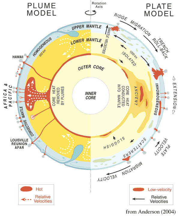
Over the last few decades the questions in deep mantle petrology have somewhat shifted from "Do hotspots really exist?" to "What is the structure of hotspots>". In the process the image has shifted from the cartoonish idea of a single jet of hot material rising from (where? That's always been a question) to play in the underside of the crust (or lithosphere - not the same thing!), creating particular melts, and causing a circular area of thermal uplift, to the much more complex ideas expressed in this 3-d seismic tomogrpahy exercise described in this paper.
For several years, a protracted sequence of earthquakes under the Indian Ocaen island of Mayotte. I thought I'd written about the Meyotte events previously - I've certainly prepared some diagrams - but if I did, I can't find it.
Short version : there have been a lot of earthquakes under the island group of Mayotte in the arm of the Indian Ocean separating Madagascar from Africa. Lots of earthquakes. Enough earthquakes to raise very real concerns about the stability of the atoll's flanks, as well as the simple risk of unadorned ground shaking.
Mayotte is a départemnt of France, so their government have to take the threat seriously. It may be unlikely to uproot the Eifel Tower, but a major earthquake (or eruption, or sector collapse) would seriously affect, or even kill substantial numbers of French citizens (and no small number of refugees and economic migrants from across the Mozambique Channel). So of course, they French take it seriously.
One part of that taking seriously has been the establisjhment of a dense array of seismographs, which assist in locating earthquakes in the body of the volcano. But it also allows the recording of changes in seismic waves from distant earthquakes which pass through and below the volcano and are affected by changes in the rock properties. This is the essence of the subject of "seismic tomography", which acquires a very thick accretion of mathematics to deconvolve the signal from the raw seismic. But that's what computers are for.
What this paper reveals is that below the SW corner of the Indian Ocean there are conduits of relatively hot, low seismic velocity rock
- moving up from the core-mantle boundary …
- to pool at the 1000km to 600km (depth) "low velocity zone" …
- then to move up further to pool again at another "low velocity zone" …
- then finally erupt (or intrude) to (near) surface
Which is fairly conventional "hotspot" theory. But there is one problem - the vertical conduits between each storage level are offset horizontally from each other by several hundred kilometres, if not more. That definitely isn't in the conventional story of hotspots.
This diagram (from Mantleplumes.org - guess their point of view!) shows - on the left panel - the traditional view of plumes ascending more or less directly from the CMB (Core-Mantle Boundary) to the base of the crust. In the right-hand panel several "low velocity zones" (LVZs) are indicated at different levels in the mantle, associated with various levels of dismemberment of subsiding plates. In contrast, the model from this Mayotte paper postulates that the same LVZs are actually conduits for horizontal movement of magma ascending from the CMB towards the surface, potentially displacing the position of the conduit hundreds or thousands of km between each level.
In short, the plumbing store has supplied the same parts, but they're now arranged differently.
The previous diagrams have been cartoons. Now comes the actual data, rendered as a cube of [difference in seismic velocity] versus northing and easting (I'm avoiding "latitude" and "longitude" because that could get really complex where you're comparing radii that differ by a factor of 2).

What do we see here? Well, it's typical geology - obviously it bears some resemblence to the cartoon (there wouldn't have been much point drawing the cartoon otherwise …), but it's also a lot more complex. The "levels" where there is horizontal melt (heat) transfer aren't level, and the "pipes" where there is vertical melt (heat) transfer aren't vertical. The "lava lamp" appearence … well, isn't the physics in both actually quite similar. It has been a long time since I had a lava lamp, but now I'm thinking that a vacuum-walled (reduce lateral heat losses) lava lamp with 3 immiscible liquids (continuum transparent; two opaque colours) would be really intereasting. I'd put a beer on it that at least one of the offices or labs of the authors has a lava lamp of some sort.
Summary
It's a much more "realisitic" feeling model. I've always been rather uncomfortable with the "cartoon" hotspot model, because the idea of such a norrow conduit persisting for so long - as well as "how the fsck do they get started?" really seemed to ask quite a lot of Earth's materials (well, any other planet's too). But the basic idea seems to have som many things going for it too. Seamount chains ; Wrightman's triple junctions ; the Yewllowstone trace under America ... it's all very tempting.
This model makes that look a lot more reasonable. It is a much more "geologically reasonable" model. "More seismic data under other complexes!" I'd really like to look underneath the incipient rift zone of East Africa - and this can't have escaped the authors either. The Yellowstone trace, OTOH would tell us a lot more about how cells (and walls and conduits) fade away. If we we're still allowed to think about basin studies and the timing of generation in petroleum provinces, this would probably get a lot of traction there.


